Modern farming increasingly relies on accurate GPS guidance to improve yield, reduce input waste, and streamline operations. This article highlights five GPS-based systems designed to boost fieldwork precision across tractors, planting, spraying, and harvesting. Compare features, ease of use, and how each option fits different farming setups and equipment brands.
Product Snapshot
| Product | Brand | Key Features | Use Case |
|---|---|---|---|
| Tractor GPS Guidance System 4inch(10cm) Accuracy | SMAJAYU | 10-inch waterproof tablet, precisionAG software, single GNSS antenna, AB line navigation | General tractor guidance without base station |
| Tractor GPS Guidance System 10inch Tablet with Precision Ag Software Activated | SMAJAYU | 10-inch touchscreen, 2.5 cm accuracy via CORS, AB line navigation, multi-language | High-precision farming tasks with AB/curve lines |
| SMAJAYU JY305 Tractor GPS Guidance System | SMAJAYU | Auto-steer ready, 10.1-inch tablet, RTK option (sold separately) | Automated steering for large-scale field work |
| Garmin dēzl OTR1000 (Truck Navigator) | Garmin | 10-inch display, custom routing for trucks, weight/height alerts | Vehicle navigation with route planning but not field/tractor-specific |
| GWURXT GPS Navigation for Car Truck (7-Inch) | GWURXT | Free lifetime map updates, multiple languages, voice guidance | General vehicle navigation as a reference tool for field operations |
Note: The table includes a mix of agricultural-focused tractor guidance systems and broader vehicle navigators for comparison. The first three SMAJAYU options are most directly applicable to farm machinery and precision agriculture workflows.
Tractor GPS Guidance System 4inch(10cm) Accuracy

This tractor guidance system integrates a 10-inch waterproof tablet with a high-precision GNSS board and precisionAG software. It includes one high-precision GNSS GPS antenna plus essential cables and tools. It supports AB-line navigation for straight or curved paths, enabling precise operations such as sowing, cultivating, trenching, ridging, spraying, transplanting, land consolidation, and harvesting across a wide range of tractors and compatible agricultural machines. The setup is designed for compatibility with various tractor brands and equipment models, enhancing field efficiency without reliance on external base stations.
Tractor GPS Guidance System 10inch Tablet with Precision Ag Software Activated

This system features a 10-inch waterproof touchscreen tablet with a high-precision GNSS board and a robust anti-interference GNSS antenna. It comes loaded with precisionAG software and multiple constellations for reliable accuracy—30 cm without RTK, and about 2.5 cm via CORS login. It supports AB-line setup for straight, curved, or historical lines, improving precision in sowing, cultivation, spraying, and other field tasks. The package includes manuals and accessories, and the solution is designed to be easy to install and move across compatible tractors. It supports multiple languages for broader adoption in diverse farming regions.
SMAJAYU JY305 Tractor GPS Guidance System

This auto-steer capable system includes a 10-inch waterproof tablet for tractor control, a steering wheel motor with a built-in controller, an angle sensor, a high-precision GNSS antenna, and required cables. RTK is sold separately. It enables automatic steering in the field, using precision GNSS data to guide tractors along AB lines and history lines with software control. The setup supports multiple tractor brands via spline configurations and aligns with field automation goals for tasks such as planting, spraying, and harvesting with improved efficiency and reduced operator fatigue.
Garmin dēzl OTR1000, 10-inch GPS Truck Navigator
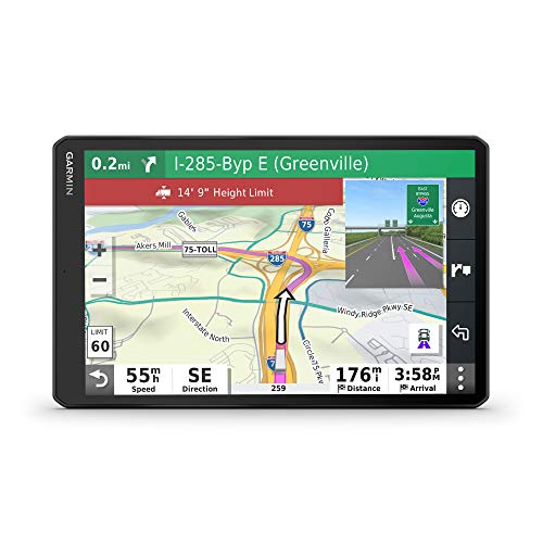
Although primarily designed for truck navigation, this Garmin model provides a large display, custom routing, and alerts for upcoming bridge heights and weight limits, which can help planning in larger farm fleets or transport logistics between fields and storage. It also supports parking information along routes, aiding efficiency for multi-site operations. It is a useful reference tool for field teams requiring reliable route planning, fleet coordination, and real-time guidance in rural road networks.
Garmin Dezl OTR500, 5.5-inch GPS Truck Navigator

This 5.5-inch Garmin model offers built-in PrePass notifications, custom truck routing, and alerts for upcoming weigh stations and bypass decisions. It supports route planning based on truck size and weight, with driver safety and efficiency in mind. While not an agricultural-specific system, it provides a compact, reliable navigation option for fleet management and field transportation planning, complementing larger tractor guidance systems when coordinating field-to-farm logistics.
Garmin dēzl OTR1000 Renewed

Renewed versions of the Garmin dēzl OTR1000 provide the same high-contrast 10-inch display and route features with a renewed assurance. They support custom truck routing and load-to-dock guidance, which can be leveraged for planning transport of harvested goods or moving equipment between fields. This option suits users seeking value without sacrificing core navigation capabilities for fleet coordination on rural routes.
Garmin DriveSmart 66 EX

A 6-inch car GPS with hands-free control and driver alerts for curves and speed changes. While not field-specific, it can complement agricultural operations by providing reliable everyday navigation for farm-to-market transport, farm supply deliveries, and contractor routes. The device emphasizes safety and user-friendly features that reduce driver distraction during long driving segments between plots or markets.
Buying Guide: Key Purchase Considerations
- Field accuracy and hardware requirements: For row-by-row farming, look for AB-line capability, curve navigation, and sub-meter accuracy. Some units offer centimeter-level accuracy via CORS with RTK options; assess whether you need RTK or base-station compatibility.
- Compatibility with equipment: Confirm tractor brands and model compatibility, including spline types or AB-line integration. Some systems specify compatibility with brands like John Deere, Case, Claas, and others. If RTK is essential, verify available subscriptions or upgrade paths.
- Ease of installation and portability: Consider how easily the system can be transferred between tractors or implements. A rugged tablet, integrated GNSS antenna, and simple wiring reduce downtime during field campaigns.
- Software features: Precision AG and AB-line tools are common, but advanced modes such as history lines, auto-steer, and multi-constellation GNSS support improve reliability in challenging environments. Language support and user manuals also affect usability in diverse crews.
- Network and subscription needs: Some systems require subscriptions for continued precision (e.g., RTK or CORS access). Evaluate total cost of ownership, including potential ongoing fees, before selecting a system.
- Safety and compliance: For large operations, ensure the device adheres to safety guidelines, including driver alerts and lane guidance for road movement when transporting between fields.
- Data handling and interoperability: Look for data export options (CSV, shapefiles) and compatibility with farm management software to streamline record-keeping and yield analytics.
- Support and updates: Active customer support, firmware updates, and software maintenance influence long-term reliability in changing field conditions and map updates.
Across these options, the primary agricultural focus should steer your choice toward tractor-oriented guidance systems with precision software, AB-line navigation, and robust field compatibility. Vehicle-focused navigators can be useful for fleet management and transport logistics but are not substitutes for tractor-specific guidance in most farming operations.